
Categories


2022
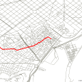
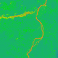
Remote sensing image mosaic line generation in python

OCR application: python development form batch recognition small application records

GEOBIA: object-oriented classification of remote sensing in python
Python's collection of various vector operations

My Development Environment Deployment
Python implementation of 6S atmospheric correction

Python Network Analysis: GIS Shortest Paths
GDAL extracts rasters and vectors from multi-vector point convolution kernels

Python batch calculation of Landsat NDVI and output tiff
Python calculates sun and sensor azimuth and zenith angles for each pixel of Landsat8